
 Continue with onX Maps
 Continue with Facebook


Recent Bugaboos conditions


|
|
Anyone have recent snow and glacier conditions for the Bugaboos? |
|
|
Have you looked at acmg.ca/mcr/archives.asp? Here's the most recent report. |
|
|
I am also interested. In particular, I saw from Friends of Bugaboos that the Bugaboo-Snowpatch col is looking pretty bad. Does anyone have any experience with the Pigeon-Snowpatch col as an ascent route? How steep is it? I want to say that the col can be reached by the Snowpatch route via class 4 to easy class 5 according to that routes information. Any further info would be huge for my planning! |
|
|
Thanks! I had not seen the new MCR report. |

|
mountainproject.com/v/condi…
link to a similar thread. doesnt have more current condition reports but answers some of the route finding questions people have. let me know if you need any further detail. |
|
|
Thanks for that other link. |
|
|
we walked under the pigeon snowpatch raps from a distance. its just a huge ice fall. Im not sure if the raps can be climbed, sorry. i didnt see a good way of getting up that. but we were headed to climb pigeon so i wasnt looking for one specifically. |
|
|
Dave Carey wrote:do you know if the first few pitches of easy rock on this climb would enable ascent to access some of the other routes (e.g. Surf's Up) mountainproject.com/v/-wies… It seems to me that this routes first pitches would allow ascent onto the Snotpatch-Pigeon colShort answer: No. Have a look at this photo: mountainproject.com/v/10697…. The Wiessner Route (SE Corner) goes up the far side of the right skyline. It doesn't go near the Snowpatch-Pigeon col or the Surf's Up ledge. |

|
Martin le Roux wrote: Short answer: No.^This. The Snowpatch Route is separated from the West Face by the monster South Face, which has I believe only big wall / aid routes so far. FWIW, this is a photo of the Pigeon-Snowpatch Col taken around June 16, 2015. 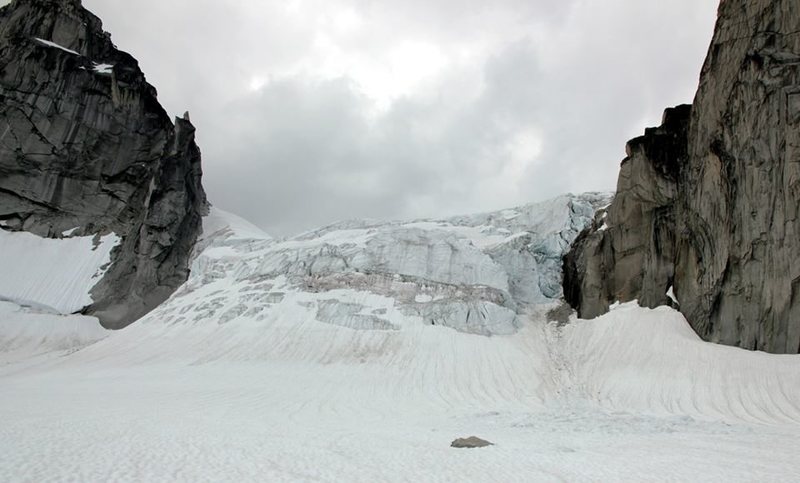 If you *really* want to access Surf's Up and the West Face of Snowpatch when the B-S Col is out, the only option is probably navigating up the Piegon Fork to the Piegon-Howser Col, then coming back down the Upper Vowell. |
|
|
Thanks for these great pictures and your help. I was having trouble reading and figuring out the Snowpatch Route in those pics. And if I may pick your brain once more. The NE Ridge of Bugaboo with a Snowpatch-Pigeon Col Rap...only an extra hour hike you think? Or is this objective just getting to be too long a day? Obviously a team experience related question, but we were already planning on 14-18 hours...just wondering what additional length we might be getting ourselves into. |
|
|
BS col is out. Don't bother unless your balls are bigger than your brain. |
|
|
Beean...Thanks for the huge info dump! That was exactly what I was hoping to find online without any luck! I think we will use this info and re-attack our route options! I am sure some of the more simplistic approaches will become more popular, but so much good rock there! |
|
|
Some great info all, thanks. With the Bugaboo/SPC col out does it make the need for an axe obsolete? Or is it still advisable for the snowpatch raps and descent? |
|
|
jason.cre wrote:Some great info all, thanks. With the Bugaboo/SPC col out does it make the need for an axe obsolete? Or is it still advisable for the snowpatch raps and descent?If you're planning on sticking to the Crescent area or only doing the NE ridge of Bugaboo then you can get by without an axe. The glacier below the Snowpatch Pigeon col is crevassed however you can scramble down loose scree under Son of Snowpatch to avoid it. This path leads to a 20m rap which bypasses a little bit of the walk back to camp but saves little, if any time. If you're planning on Pigeon then take full glacier kit. |
|
|
Brassmonkey wrote:Beean, any chance you have pictures of the bs col and the crevasses opening up on the upper vowell? Just interested to see how much it has changed since I was in there three weeks ago, thanks!Funnily enough I don't, sorry. I didn't take any pics of either of those for some reason. I guess I ignored the col because it was out and I was too keen to get up and down Pigeon to stop and take some pics of the glacier. |
|
|
I did the B-S col rap route in early July and it's anchor locations are protected from rockfall (although a bit hard to find). Takes a double rope rap to clear the schrund from the third station. |
|
|
Great thread and thanks for all the beta folks. |
|
|
BFK wrote:Great thread and thanks for all the beta folks. I'm scheduled to head out to the bugs on Aug 15th and based on what I'm reading it sounds like it may be wise to divert to Squamish! Question for Beean: Are the Howser Towers accessible at this point? And I guess more importantly is the rap/descent across the upper Vowell passable? Any updated beta is much appreciated.The Howsers were accessible via the Pigeon-South Howser col when I was there. But that was a week ago. I would say that given an early start, you can still approach Pigeon from the hut. A freeze inspires confidence on snow bridges. I was a little nervous coming down in the afternoon. You can bypass the upper Vowell descent by heading across to Snowpatch and rapping, it's not a big deal at all. |
|
|
Thanks Beean! We're also keeping a keen eye on the weather which seems to show a low pressure system moving in over this weekend. Thinking more and more that Squamish might be a safer bet. |
|
|
Just providing an update for those reading now that I've returned. We did Pigeon and bugaboo spire and they are absolutely both still in. To get to pigeon, we climbed the bugaboo glacier where yes there were lots of exposed crevasses and a couple bridges, there was a well traveled trail that made its passing not to bad. |


