
 Continue with onX Maps


All Locations >
Arizona
> Northern Arizona
> Flagstaff Area
> Upper Pumphouse…
> Ultimates
> Ultimates East
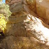
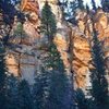
> Lorax (5.9+ 5c 17 VI 17 E1 5a)


ID 109774962 ·
·
Copyright Violation?


Rate Photo

Wiled Horse
Dec 1, 2014
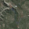
“The "Lorax Loop", you ask? Here is the approximate map. Also refer to secret passage beta map (roughly outlined inset box). Now that 253G is officially closed to motor vehicles, this ultra-adventurous option may save you a little time on the hike back.
Park at either parking locations marked in red 'P' along 253. Walk 253G and approach down into the Ultimates as you would for the Secret Passage approach (red dots). Climb the Lorax route (marked "L").
When you top out, head to the west (blue dots) and then follow game trails switchbacking the STEEP hillside. At the top of the hill, contour around to the south-east and then south. Eventually things will flatten out a bit where you can join FR253. This is not marked, requires a bit of backcountry navigation skill, and I would not recommend trying it for your first time in the dark.
approx approach time: 45 min
approx hike back: 40 min
”


0 Comments