
 Continue with onX Maps
 Continue with Facebook


Routes in Mt. Winchell

|
East Arete T 3rd 1- 1 I 1 M 1a |
|
|
McKenzie's Arete T 5.10 6b 20 VII- 19 E2 5b |
|
|
Southwest Chute T 5.6 4c 14 V 12 S 4b |
|
|
West Arete T 5.8+ 5b 16 VI- 15 HVS 4c PG13 |
Order Wrong?
Sort Routes
| Type: | Trad, Alpine, 1500 ft (455 m), Grade III |
| FA: | WK Davis, Jack Riegelhurth (1938) |
| Page Views: | 1,715 total · 14/month |
| Shared By: | fossana on Jul 6, 2014 |
| Admins: | Chris Owen, Lurk Er, Mike Morley, Adam Stackhouse, Salamanizer Ski, Justin Johnsen, Vicki Schwantes |
Your To-Do List:
Add To-Do ·
Your Star Rating:


Use onX Backcountry to explore the terrain in 3D, view recent satellite imagery, and more. Now available in onX Backcountry Mobile apps! For more information see this post.
Description


About six years ago in my search for undiscovered Sierra classics I came across the SW Chute in Secor, rating "class 4-5". Misha's W Arete route description re-inspired me to check out this line, as it joins the spectacular W Arete past the more difficult sections. My friend Chris K gave me rave reviews on the W Arete, but I wasn't sure I wanted to onsight solo it after hearing Chris' description and especially after reading Misha's. I figured the SW Chute would be a good compromise.
Based on a Roper and Waddell variation (also described by Secor) that bypasses the bottom section I was expecting to find 5th class only in the first 400 ft, the rest class 4. Instead I found some very exposed mid-5th (5.6ish) on the arete, not including my variation of gaining the arete early.
Trailhead
From the town of Bishop, head west on W Line Street (highway 168 W). Go ~14.7 miles and turn left on S Lake Rd. At ~7 miles the road ends at the trailhead. Just before the parking lot the road splits, the right going to the boat ramp and the left to the trailhead. Note that some of the parking places are reserved for daytrippers.
Amenities
There are pit toilets and bear boxes at the trailhead. Camping along S Lake Road is in designated areas only. Primitive camping is available off of 168 unless otherwise posted. Manor Market (3100 W Line St) is the last gas and real grocery store as you leave town.
Red Tape
A permit is required for overnight trips between 1 May and 1 Nov. As of this posting, 14 of 36 permits are held for walk-ins, the rest reservable. Contact the White Mountain Ranger station in Bishop (798 N Main St, Bishop, CA 93514 760.873.2500) or the Inyo National Forest website for more details. Obvious places to camp include Bishop Lake and Dusy Basin, but options are plentiful.

Approach
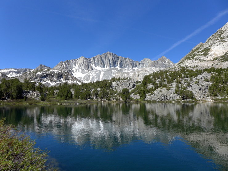
From the trailhead (9820') hike 6.0 miles on the main trail to Bishop Pass (11,972'). There are plentiful water sources along the way. Water treatment is recommended due to the number of human, canine and equine visitors. The trail will drop down to Dusy Basin; instead contour SE off-trail along the base of Mt Agassiz toward Thunderbolt Pass. There may be a faint climbers trail and cairns, but it's pretty difficult to get lost. Look for some low white cliffs at the base of Mt Winchell. The routes starts just to the right.
The Route
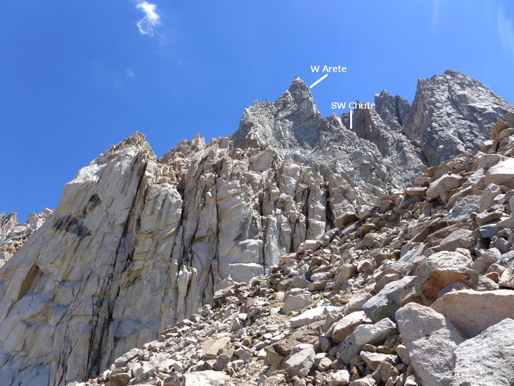
Starting just to the right of the white cliffs ascend the headwall into the broad chute. There are several ways to go with varying difficulty. Continue up the chute until it pinches off, then go left to gain the W Arete.
variation 1 (per Secor): Instead of starting in the chute, climb a wall several hundred feet left of the SW Chute. After ~400 ft traverse right across the W Arete, continuing into the SW Chute proper.
variation 2: For more ridge traversing gain the ridge after the second major tower where the angle eases up. Note that this is the second prominent tower as viewed from the chute, not as for the start described by Misha.
Continue up the W Arete until the NW Ridge joins in from the left. Take the NW Ridge to the summit. To keep it ~5.6 you may need to deviate slightly from the most direct line up the ridge, most often on the right.

Location
Finding the Route
The SW Chute lies just to the right of the prominent W Arete. As you approach Mt Winchell look for the band of low white cliffs and aim for the righthand side. The SW Chute is the leftmost of the 2 prominent chutes in the middle of Winchell.
![]() location of the SW chute
location of the SW chute
Descent
There are a number of options for the descent with varying degrees of difficulty. Assuming that you haven't set up a car shuttle at Glacier Lodge:
![]() the N slabs descent route
the N slabs descent route
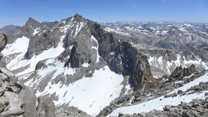
![]() another view of the descent (chartreuse dot marks the top of the N slab descent, the orange dot is the top of Agassiz Col)
another view of the descent (chartreuse dot marks the top of the N slab descent, the orange dot is the top of Agassiz Col)
Once back on the SE side of the Palisades retrace your steps back to Bishop Pass trail.
The SW Chute lies just to the right of the prominent W Arete. As you approach Mt Winchell look for the band of low white cliffs and aim for the righthand side. The SW Chute is the leftmost of the 2 prominent chutes in the middle of Winchell.
Descent
There are a number of options for the descent with varying degrees of difficulty. Assuming that you haven't set up a car shuttle at Glacier Lodge:
- From the summit downclimb the E Arete until you can contour around to Winchell Col, the low point between Thunderbolt (the peak to the SE) and Winchell and cross back over to the SW side of the range. You may have to rap to get to easier terrain without losing too much elevation.
- (the way I went) From the summit downclimb the E Arete for short distance, then drop down the slabs to the north until you can contour to Agassiz Col, the low point between Winchell and Agassiz (the peak to the NW). The downclimb was class 4 the way I went. Descending to col to the SW side of the range is class 3.
- For the more adventurous/motivated follow the NW Ridge to Agassiz Col or continue on to the summit of Agassiz. Expect difficulties up to 5.9.
- Descend the route, which may require leaving rap slings.

Once back on the SE side of the Palisades retrace your steps back to Bishop Pass trail.


2 Comments