Mountain Project Logo

Granite Mountain Wildfire?

Original Post
Anonymous · · Unknown Hometown · Joined unknown · Points: 0

From the pictures, it looks like the fire is smack dab in the middle of the Granite Mountain climbing areas.

Hope everyone is safe and it doesn't cause too much damage to homes or GM.

JJ Schlick · · Flagstaff, AZ · Joined May 2006 · Points: 11,803

Looks pretty freakin close to me, but they said it was moving west... Started west of the main wall too.

search.yahoo.com/r/_ylt=A0o…;_ylu=X3oDMTByZ3RtN3J1BHNlYwNzcgRwb3MDMgRjb2xvA3NrMQR2dGlkAw--/SIG=13b8fnk0t/EXP=1371631655/**http%3a//www.myfoxorlando.com/story/22624052/2013/06/18/doce-wildfire-burns-near-prescott

MacM · · Tucson/Preskitt, AZ · Joined Feb 2010 · Points: 675

As of about 8pm the fire reached the top north ridge on GM. I believe it was at about 5,000acres at the time too. The wall proper and approach from the south isn't touched (yet) but the fire started on the south and has swept around to the north and west sides of GM.

dcourier.com/main.asp?Secti…

The roads are all blocked off due to evacuations, but from what I could see based on where the smoke was coming from and where I noticed the flames were tonight. Here is an entirely theoretical speculation of how the fire is right now:

Granite Mountain Fire '13

Winds are not looking favorable at all for the next few days (Gusting 28mph). Hopefully they manage to get some containment on it and direct it away from the Wilderness Area. As of right now it is 0% contained.

-Mac M

tims schneider · · Unknown Hometown · Joined Jun 2013 · Points: 5

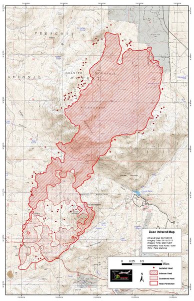
Recent Heatmap from this afternoon.. looks like it went right up and over the wall??

Doce Fire Heat Map

MacM · · Tucson/Preskitt, AZ · Joined Feb 2010 · Points: 675

Wow, I really hope that map isn't correct. From the looks of it over there the fire was on top of the wall, but not at the base. I guess we'll just need to wait until access is allowed and check it out for ourselves.

Maybe that approach won't be such a pain anymore...

-Mac

JJ Schlick · · Flagstaff, AZ · Joined May 2006 · Points: 11,803

What a bummer. Do they still think natural causes? Rock slide with sparks?

Wiled Horse · · Unknown Hometown · Joined Dec 2002 · Points: 3,669

eerily reminiscent of what Hayman did to Sheeprock about 11 years ago. Hopefully it doesn't get that bad.

BTW, one source says it was human caused...

JJ Schlick · · Flagstaff, AZ · Joined May 2006 · Points: 11,803

Stupid humans.

CO_Michael · · Unknown Hometown · Joined May 2008 · Points: 956

Updated Info on INCI.

inciweb.org/incident/3437/

--- Invalid image id: 108202867 ---

Doesn't look very good. Looks like it went right to the front porch.

Wiled Horse · · Unknown Hometown · Joined Dec 2002 · Points: 3,669

like mentioned above, the silver lining is maybe this will clean up the approach and descent.

MacM · · Tucson/Preskitt, AZ · Joined Feb 2010 · Points: 675

That is a really good point, I'm curious myself. However if it's bad enough up there the rock might need the extra month(s) of monsoonal rain to wash off the char anyways before it would even be climbable (presuming the falcon closures get lifted)...man, I really hope it isn't that bad. Such. A. Bummer.

Hopefully that ONE tree on the Front Porch didn't get torched.

Zach Myers · · Durango, CO · Joined Oct 2012 · Points: 50

I was mountain biking today a brought a camera along to get some images of the fire, from this view it looks like the main cliff/front porch area is safe for now, but the summit is getting torched

Main cliff untouched, summit area crags likely very hot

Firefighting crews in large helicopters working hard to contain the fire

Paul Paonessa · · Phoenix, AZ · Joined Jul 2007 · Points: 65

I hate to see that great ancient old juniper tree on top of The Crawl damaged. Always enjoy walking by that old guy on the way down.

While we all wait and joke, maybe the fire will clean up the approach trail. There is a real threat of major soil erosion on those slopes from the summer monsoon rains.
I hope we don't see catastrophic soil failure at the base of cliff if the fire has reach that far. The mountain may need some TLC ( volunteer trail work days), from the climbing community.

MacM · · Tucson/Preskitt, AZ · Joined Feb 2010 · Points: 675

Paonessa,
From news report..

"A juniper tree, which could be the world’s largest, was saved by fire crews who cut vegetation around it, said Jason Williams of the Prescott National Forest. The tree is 14 feet in diameter." Looks like it will be there for hopefully many more years.

Also, from those pictures that Zach posted, it definitely looks like the main wall and, for better or worse, the approach was spared from the fire. I looked over at the Waves of Rock area and I believe I saw a red slurry line across the face from top-bottom. Not sure how permanent that will be, hopefully it dissolves quickly.

Not sure when the trail will be opened again, but I'll try to head out there soon to get some facts about the final damage.

-Mac

Zach Myers · · Durango, CO · Joined Oct 2012 · Points: 50

I took those pictures on Thursday afternoon but I heard from a few folks that watched the fire on Thursday night and saw it crawl out of the top basin and possibly down near the right side of the main cliff, I don't know how true this is or how much has burned in that area but hopefully the damage along the cliff and front porch area will be minimal.

Larry Coats · · Unknown Hometown · Joined Dec 2006 · Points: 1,470

Sorry to bear bad news, but it looks like the climbing area was fully engulfed early on (before Zach's photos above). I found this image on Flickr Granite Mt fire on Wednesday June 19th - you can see a bit of smoke still coming from burning vegetation from above and to the right of the crag in Zach's pic. The thick plume coming from both sides of the Flying Buttress has me particularly bummed about the condition of the Classic, Coke Bottle, and the Front Porch area in general. Now the hope is that the fire wasn't too hot under most of the crag when it burned through, but the Forest Service infrared data aren't promising.

And let's hope the juniper in the above news clip is indeed this old specimen....

The old juniper above the Swamp Slabs at Granite Mountain (Jim Haisley photo of Paul Davidson circa 1980)

Zach Myers · · Durango, CO · Joined Oct 2012 · Points: 50

That image taken Wednesday is heartbreaking, it looks like the whole Mountain is going to be quite a different place. This whole event is very unfortunate, having been caused by the negligence of one or several very stupid people who couldn't tell that it hasn't rained in a while.

Larry Coats · · Unknown Hometown · Joined Dec 2006 · Points: 1,470

Further update from the Prescott Daily Courier, based on insight from hotshots on the scene and afterwards:

"But several other trees that are special to the rock climbing community may not have made it.

"The rock quality up at Granite Mountain is comparable to Yosemite," Williams noted, so that rock climbing community is nationwide.

A lone shady pine tree for which Pine Tree Ledge is named, and a gnarly old juniper above it, appeared to be blackened when he looked at them with binoculars, Williams said. He hopes to hike up there this week to take a closer look.

Climbers have to climb through the huge juniper to get down the cliff face, Williams said.

"I've climbed it in the moonlight and had ringtail cats looking down at me from that tree," he said.

A prominent piñon on a flat ledge named the Front Porch below the climbing face might have survived, Williams said."

And the saved juniper referenced above by MacM was not the Swamp Slab juniper: Daily Courier article

MacM · · Tucson/Preskitt, AZ · Joined Feb 2010 · Points: 675

Thank you for posting all of that information Larry. I should have cited that quote I sated earlier from The Prescott Courier about the Juniper so others could confirm which one it was.

After reading the article I have kind of lost some optimism I had before about the wilderness area, mostly the basin and up towards the main wall, not being affected. Also, as much as it dissappoints me that the main trail won't be back open for a few months it makes a lot of sense. I can't imagine how the flooding is going to be once the monsoons roll in, and the erosion that will be occurring is going to probably be substantial.

I feel that the Prescott Climber's Coalition (PCC) could start taking action on how we can assist in erosion prevention and trail improvements in the area. Maybe in collaboration with Greater Northern Arizona Republic (GNAR) a lot of good work could be accomplished.

That's just food for thought, I only know of the organizations and some of the people that are in them. I'm not exactly sure who heads them, or if the PCC is still around.

-Mac

Peter Franzen · · Phoenix, AZ · Joined Jan 2001 · Points: 3,730

Yikes, this is all really sad. Just 10 days ago I was thinking that I should go up and check out Granite Mountain; I haven't been up there yet since moving here 2 years ago.

I guess I'll have to wait a bit longer. :(

Holden Green · · Unknown Hometown · Joined Jul 2013 · Points: 0

Has anyone been up to the front porch to see the damage yet? If anyone has pictures of it please post! Heartbreaking to think one of the finest climbing areas in the country went up in flames. just hoping someone will post a photo showing that the rock didn't take too much damage and is still beautiful and climbable. Always thinking of you Granite Mountain

Guideline #1: Don't be a jerk.

Arizona & New Mexico
Post a Reply to "Granite Mountain Wildfire?"

Log In to Reply
Welcome

Join the Community

Create your FREE account today!
Already have an account? Login to close this notice.

Get Started