
 Continue with onX Maps
 Continue with Facebook


Routes in The Red Slab

|
1976 Crack/chimney T 5.8 5b 16 VI- 15 HVS 4c |
|
|
And Now for Something Completely Different T 5.9 5c 17 VI 17 HVS 5a R |
|
|
Back Scratcher T 5.9 5c 17 VI 17 HVS 5a PG13 |

|
Bumblies For Breakfast S 5.10a 6a 18 VI+ 18 E1 5a |
|
|
Corner, The T 5.8 5b 16 VI- 15 HVS 4c |
|
|
Diamondback S 5.10b 6a+ 19 VII- 19 E2 5b |
|
|
Fun 'n' Games T 5.9- 5c 17 VI 16 HVS 4c |
|
|
Jenga S 5.4 4a 12 IV 10 VD 3c |
|
|
Lounge Lizard S 5.10b 6a+ 19 VII- 19 E2 5b |
|
|
MK '74 T,TR 5.9 5c 17 VI 17 HVS 5a X |
|
|
Pink Slip S 5.12b 7b 26 VIII+ 26 E5 6b |
|
|
Rattle and Scream S 5.10a 6a 18 VI+ 18 E1 5a |
|
|
Rubics S 5.9- 5c 17 VI 16 HVS 4c |
|
|
Slip and Slide S 5.10d 6b+ 21 VII+ 21 E3 5b |
|
|
Slip It In S 5.11b 6c 23 VIII- 23 E3 5c |
|
|
Snakes For Snacks S 5.10a 6a 18 VI+ 18 E1 5a |
|
|
Spring Fever T,S 5.10+ 6b+ 21 VII+ 20 E3 5b |
|
|
Trundelero S 5.10b 6a+ 19 VII- 19 E2 5b |
|
|
Vapor Trail S 5.9 5c 17 VI 17 HVS 5a |
|
|
Wicked Game S 5.10d 6b+ 21 VII+ 21 E3 5b R |
| Unsorted Routes: | |
Order Wrong?
Sort Routes
| Type: | Trad, 350 ft (106 m), 4 pitches |
| FA: | scruff seeker |
| Page Views: | 2,756 total · 12/month |
| Shared By: | Leo Paik on Apr 13, 2005 |
| Admins: | Leo Paik, John McNamee, Frances Fierst, Monty, Monomaniac, Tyler KC |
Your To-Do List:
Add To-Do ·
Your Star Rating:


Use onX Backcountry to explore the terrain in 3D, view recent satellite imagery, and more. Now available in onX Backcountry Mobile apps! For more information see this post.
 Access Issue: Seasonal Raptor Closures/CDOT Road Work
Details
Access Issue: Seasonal Raptor Closures/CDOT Road Work
Details
Please be aware of the annual raptor seasonal closures!
Raptor Closures Effective February 1-July 31
Visit: jeffco.us/open-space/news/2…
Tunnel 1 closure
For more details visit: jeffco.us/open-space/alerts…

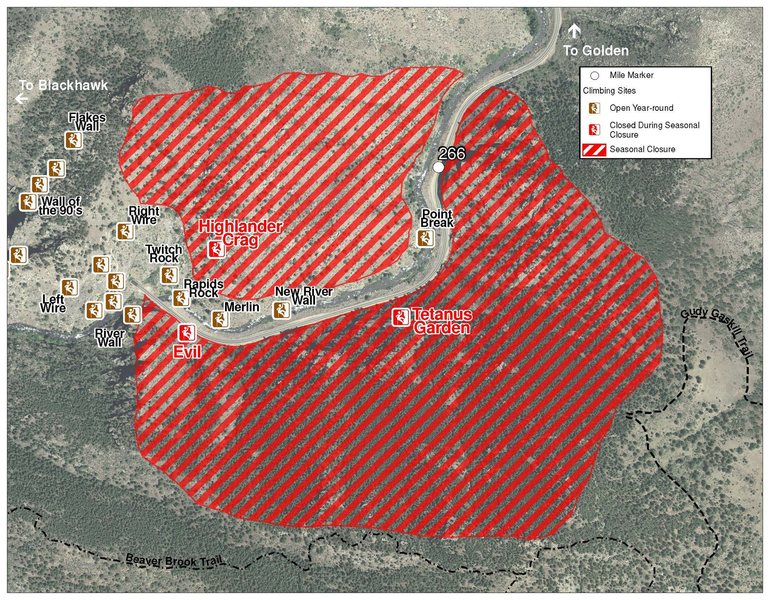
The two areas Jefferson County Open Space intends to close in Clear Creek Canyon, shown on the attached maps, encompass the active eagle nests. If the Clear Creek eagles continue to nest in the active nests, these areas will remain closed from February 1 through July 31. If the eagles choose different nesting sites, the closures will be adjusted accordingly to protect those eagles during their breeding season.
Currently, rock climbing areas that fall inside of the seasonal raptor closures include:
Blonde Formation
Bumbling Stock
Evil Area
Ghost Crag
Highlander
Skinny Legs
Stumbling Block
Tetanus Garden
Fault Caves
June 7, 2021 - TBD: Highway 6 is currently doing full road closures from Sunday night to Friday morning every week. The closure is from the junction of Highway 119 and Highway 6 to the junction of Highway 40 and Highway 6 (mile post ~260 to ~257). Vehicles that remain in the closure will be towed at owners expense.
Sundays: 7PM-4AM
Monday-Thursday: 4PM-4AM
Raptor Closures Effective February 1-July 31
Visit: jeffco.us/open-space/news/2…
Tunnel 1 closure
For more details visit: jeffco.us/open-space/alerts…
The two areas Jefferson County Open Space intends to close in Clear Creek Canyon, shown on the attached maps, encompass the active eagle nests. If the Clear Creek eagles continue to nest in the active nests, these areas will remain closed from February 1 through July 31. If the eagles choose different nesting sites, the closures will be adjusted accordingly to protect those eagles during their breeding season.
Currently, rock climbing areas that fall inside of the seasonal raptor closures include:
Blonde Formation
Bumbling Stock
Evil Area
Ghost Crag
Highlander
Skinny Legs
Stumbling Block
Tetanus Garden
Fault Caves
June 7, 2021 - TBD: Highway 6 is currently doing full road closures from Sunday night to Friday morning every week. The closure is from the junction of Highway 119 and Highway 6 to the junction of Highway 40 and Highway 6 (mile post ~260 to ~257). Vehicles that remain in the closure will be towed at owners expense.
Sundays: 7PM-4AM
Monday-Thursday: 4PM-4AM
Description

This is a scruffy multi-pitch trad climb in Clear Creek canyon. Unfortunately, it is not great, not even good. It lies on the SW face of The Red Slab (aka Rainbow Wall per P. Hubbel). Colorado Crags by P. Hubbel, p. 147 has an topo of a bit of this climb. When driving down the canyon, it catches the eye of a trad climber with a moderate-sized face. This is the worse of the two on this face; Fun 'n Games, is a much better. This route is loose, grungy, and even slimy when wet (P2). The finish of P2 can be scary with a large boulder perched precariously at its top. This first two pitches of this face stay shady until afternoon; however, P3 & P4 bask in sun earlier.
Approach this as for the Red Slab, parking South of US Hwy 6 just East of the bridge below The Little Eiger. I prefer the lower traverse that starts below the level of the road. Arrive below the Red Slab via the obvious trail, continue West past this on a still obvious trail. The final bit is talus-covered. The start is likely share with Fun 'n Games.
P1. Follow a sort-of-crack angling left through a bush to the left side of the obvious prow/bulge to an area with solid footholds but loose rock on the right, 5.7, 170 feet. There appears to be a sling rap in the loose gully to the left.
P2. Continue up along the large, left-facing dihedral. There is less of a crack here than it appears from the ground. Near the top, the terrain gets looser & grungier. If wet, it is quite slimy & intimidating. A #4 Camalot is nice just below the crux. A #2 Camalot protects your 2nd once you pass the crux. Belay on a large ledge. 5.8 PG-13, 100 feet.
P3. Go up a block finishing on a nice arête, 5.5, 40 feet.
P4. Move the belay about 140 feet to the left side of a large dead tree below the summit block. Fire up the shallow, right-facing dihedral/crack to the left of the dead tree. This is nice. 5.7, 40 feet.
Hike off to the far left probably 300m and angle back to the base on mostly loose, hiking terrain.


1 Comment