|
|
Nate Farr
·
Apr 8, 2013
·
Flagstaff, AZ
· Joined Feb 2008
· Points: 65
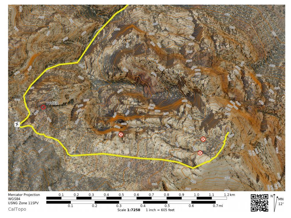
Anyone have GPS coordinates or information for the Mt. Wilson descent? Any leads on good specific beta? I'd like to have something other than dead reckoning if I happen to come down at night in a couple weeks.
|
|
|
J. Thompson
·
Apr 9, 2013
·
denver, co
· Joined Jan 2001
· Points: 1,425
Here it is.
You're going to hear a bunch of different opinions/ beta about this.
BUT!
This is it.
Go down Oak creek canyon.
After topping out go all the way back to the limestone band...there will literally be a line that goes from red to gray.
There is also a small groove of mature ponderosa pine trees right there...they are the only Pondo's any where close.
Then head down the canyon. There are 2 very short rappels. You can also down climb them if you like (I have).
There are several benefits of going down Oak creek (Vs. 1st creek).
Most of the walking is over open slabs...vs. scrambling up and over boulders.
You can park at the Oak creek trailhead...knocking off A LOT of mileage on the approach and descent.
Use the above beta and make your day better!
HAVE FUN!
josh
|
|
|
Robert Fielding
·
Apr 9, 2013
·
Thousand Oaks, CA
· Joined May 2011
· Points: 195
I have always went down to the limestone bands to first creek! But either way it's a really mellow descent.
|
|
|
Robert Fielding
·
Apr 9, 2013
·
Thousand Oaks, CA
· Joined May 2011
· Points: 195
Awesome. I'll def check out the oak creek descent next time...
|
|
|
Keith Robinson
·
Apr 9, 2013
·
Unknown Hometown
· Joined Aug 2008
· Points: 10
Oak Creek is far better than the gully scrambling in 1st Creek... my first time down. On my latest trip down we took Oak Creek and it was straight forward, equally cairned out, etc.
|
|
|
Dow Williams
·
Apr 9, 2013
·
St. George, Utah; Canmore, AB
· Joined Mar 2006
· Points: 240
I have been down both sides on several occasions....Oak Creek is faster....several specific points that make it a bit quicker....
1. park at the first Oak Creek pullouts (further north or east)...not the signed one if you are heading for any routes on the right side of the mountain, i.e. Aeolian Wall. This parking area is best in alignment with the Wilson Pimple and will save you time and energy at the end of the day.
2. From the summit, traverse southwest early to cross over a deep cut gully so you do not have to lose and then regain a bit of elevation. Think to yourself to gain the center of the landscape at the beginning as you head west.
3. Everyone mentions the Ponderosa Pines...there is another obvious landmark, a balanced rock tower to your right. Circumvent it to the right and descend west into the south fork of Oak Creek.
4. One brand new (blue) fixed hand line as of last week is to the right, first steep obstacle you come to. Some might be more comfortable rappelling it, I just hand line it down. Two more steep sections (shorter than the one above) that have existing tat on trees/bushes above them if you are not comfortable downclimbing/sliding the slick rock. Use your own rope as a quick hand line to descend if you would rather.
5. The side trail back to your vehicle is just after an official sign on the main trail saying 1 mile to the Oak Creek loop pullout. They are referencing the loop road trailhead. Turn right here at a cairn, then left on a well traveled trail and follow it straight to your vehicle.
This option is faster than First Creek by about 1 hour or so. Good Luck.
|
|
|
Eric D
·
Apr 9, 2013
·
Gnarnia
· Joined Nov 2006
· Points: 235
Be patient on the Oak Creek descent. Do not cut down too early. Better too late than too early.
|
|
|
Andrew Higgins
·
Oct 25, 2018
·
Unknown Hometown
· Joined Dec 2016
· Points: 0
After attempting the Oak Creek descent given the above information and bailing into the more straight-forward First Creek drainage, I have some thoughts:
-Do not be fooled by a couple of large cairns on the first major slab encountered on the right (north) side of the descent trail - they even correspond with a grove of Pondo's, but lead nowhere. Continue up and over the ridge instead.
-As of October 2018 there exists a fire ring at a low col on the limestone band. From this point a well-cairned trail leads down into the First Creek basin (left). This descent was very straightforward
-While this col DID meet the criteria of a "limestone-sandstone line", there were NO ponderosas within sight, nor was there an obvious "balanced rock tower". Perhaps if we had committed to descending towards Oak Creek canyon down a wide plateau on our right we may have encountered these landmarks. However, Iit was difficult to differentiate animal trails from human as there were no cairns indicating the correct trail into Oak Creek at this point.
This descent was not as straight-forward as others made it seem. From summit to vehicle following the well-cairned First Creek descent however a party could reasonably expect 3 - 3.5 hours.
|
|
|
Ryan Marsters
·
Oct 25, 2018
·
Golden, CO
· Joined Jan 2011
· Points: 1,431
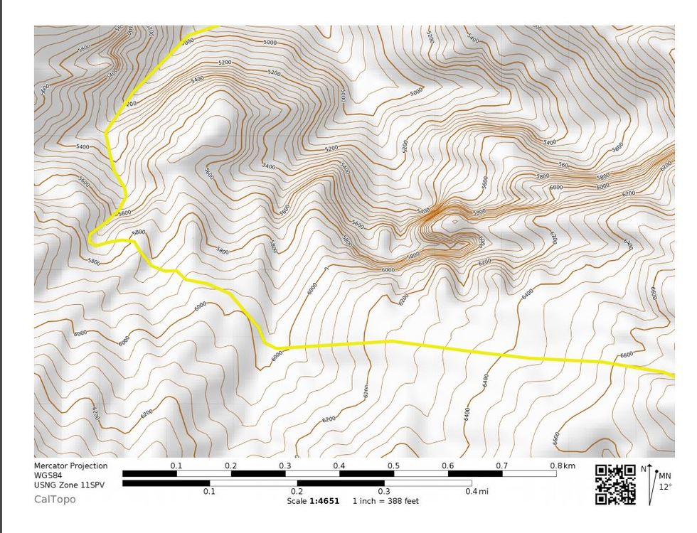
From the summit: - Head SW on slabs for almost 1000 feet exact. Avoid the temptation to drop into any gullies earlier or sidehill along the slabs.
- Drop into a west facing scree/tree gully with faint trails. Alternatively descend slabs to west with minor scrambling.
- Almost due west for 0.55 miles and cross a north facing drainage
- Contour down and NW. Go all the way past a few more drainages until hitting a big limestone wall. It would be hard to go any further NW beyond the limestone cliffs. This is very distinct.
- Avoid taking a drainage north too early, else you're guaranteed a rappel or two. The "tower" is at a saddle prior to one false drainage (that works with a rap).
- Key point for the drop in:
36.0945, -115.4986
- Scree ski down to some bushes at the start of the drop. It's slick and sketchy below, but there's a hidden tree/bush rap station (~80 ft drop) along a ledge skiers left that's reasonable to get to. A little further left is a slick calcite-smeared but doable 4th class downclimb.
- Once in the drainage, follow it out with lots of doable but micro-scale routefinding for 4th class and low fifth mini drops. We encountered 2 fixed ropes and one spicier downclimb.
- The downclimbing slowly transitions to the usual boulder hopping. Near the mouth of the canyon, look north/left with some short uphill for the good trail out to the highway, as opposed to staying on the poor trails nearer the drainage.
![]() ![]()
|

 Continue with onX Maps
 Continue with Facebook