Mountain Project Logo

Massive power lines in front of Rocky Mountain National Park?

responsiblelines · · Unknown Hometown · Joined Jan 2012 · Points: 70

Hi all. Thanks to all the 72 people who wrote in today alone. You're awesome!

There are 4 hours left in the comment period Let's shoot for 100!

Estes Park Scenic Turnout overlooking Lumpy Ridge and Rocky Mountain National Park where WAPA proposes this industrial scale project. Towers and lines currently don't block this view (artist rendition). They may unless we all stand up and write in.

Let's all tell them to withdraw plans for a re-route and rebuild along the USFS Designated Utility Corridor for the good of everyone.

The clear cuts and towers WAPA proposes cannot be undone, but they can be prevented.

WAPA's Public Comment period ends tonight, January 31st, 2012 @ midnight!

Take Action Here: responsiblelines.org/takeac…

JoeP · · Littleton, CO · Joined Sep 2006 · Points: 0
Mike Lane wrote: And, WTF is up w/ zero media coverage about this? Like everything else involving money, they'll wait until its set in stone before the wailing and gnashing of teeth so they can pretend to still be legitimate.
You got a crystal ball or what? 9News reported the story tonight and said "today is the last day for comment." More like, tonight is the last hours for comment...
responsiblelines · · Unknown Hometown · Joined Jan 2012 · Points: 70

Thanks to everyone who wrote in from all over the country to request that WAPA withdraw the re-route, and rebuild the power line along the pre-existing clear-cuts within the USFS Designated Utility Corridor. WAPA's "public scoping" comment period closed on January 31st, 2012, and the USFS is the one agency who still has a say.

Now, It all hinges on the USFS...

The USFS can require WAPA to steer this project away from the public's scenic federal byways, overlooks, and the highly scenic public access trailhead, campgrounds, and recreational use areas of Roosevelt National Forest where no utility corridor exists.

Specifically, the Arapaho-Roosevelt National Forest, Canyon Lakes District Office in Fort Collins, CO has the power to deny WAPA's Special Use Permit application currently on file and require them to site this project, instead along the USFS Designated Utility Corridor. So far, it's been 9 months, and the USFS has indicated that they will actually re-write their own Forest plan standards to fit this project. Something's definitely wrong with this picture!

We have 80 days to convince the USFS to take a stand for the public good and for the public lands they've been charged to manage. If enough of us call, write, and email the USFS, we can make a difference!

Responsiblelines.org is updated and ready to roll.

Comments will now be addressed directly to the USFS until April 22, 2012. If you've just heard about this, or even if you've already commented to WAPA, now is your chance to address the USFS while they decide to act for the public good, or not.

RMNP as seen from Roosevelt National Forest boundary standing just uphill from where WAPA plans to clear cut this re-route, unless the public says otherwise.
Here's how you can help:

responsiblelines.org/takeac…

NickinCO · · colorado · Joined Sep 2010 · Points: 155

your link comes up as "no results found"

Try this

Take Action

responsiblelines · · Unknown Hometown · Joined Jan 2012 · Points: 70

Thanks for the link fix.

DaveC · · Louisville, CO · Joined Feb 2006 · Points: 65

Sent your form email with minor edits, since the (ResponsibleLines) website says the comment date is April 22.

While I am personally down with the issue (and giving it a bump with this post), I am not totally keen with MP as an advocacy forum for land use issues unless there is direct impact on climbing access. The cause will do better if it can grow from this MP thread into more appropriate forum.

Good luck. I signed up for email alerts, so contact me there with updates.

responsiblelines · · Unknown Hometown · Joined Jan 2012 · Points: 70
DaveC wrote:I signed up for email alerts, so contact me there with updates.
Will do. By the way, here's current conditions at the Divide as of yesterday...
Longs Peak Feb 2012 seen from Roosevelt National Forest boundary just uphill from the public access trailhead, where WAPA plans to clear cut this re-route, unless the public says otherwise.
Joe Huggins · · Grand Junction · Joined Oct 2001 · Points: 105
s.price wrote: My question as well.
Yeah,I want to know as well.It seems to me that the esthetic considerations of burying the lines are bolstered by the highly bombproof nature of the installation.
Roxy · · Estes Park · Joined Feb 2009 · Points: 55

letter sent

responsiblelines · · Unknown Hometown · Joined Jan 2012 · Points: 70
Recent article foreshadows what's currently being proposed for the foreground of Rocky Mountain National Park:

The Platte River Power Authority has disregarded requests by the City of Fort Collins, and they are currently blasting new clear cuts, towers, and lines through Pine Ridge Natural Area. This is exactly what's being proposed along the scenic travel corridor into Estes Park, CO where people travel thousands of miles to get their first views of Rocky Mountain National Park and the Continental Divide.

coloradoan.com/article/2012…

The people of Fort Collins said they had little notice and little time to stop this, but they, along with the rest of the country still have a time to tell the USFS to require WAPA to use the designated Utility Corridor, to cancel this unnecessary, publicly damaging, and costly re-route.

USFS Designated Utility Corridor in red. Rather than re-build the line here, WAPA is proposing a costly and damaging re-route away from the Pew Crocker Ranch and into the Public's scenic byways and National Forest where no utility corridor exists. We still have a little time to change the course of this damaging proposal, but the proposed construction start date is Spring 2012 (Click to Enlarge).
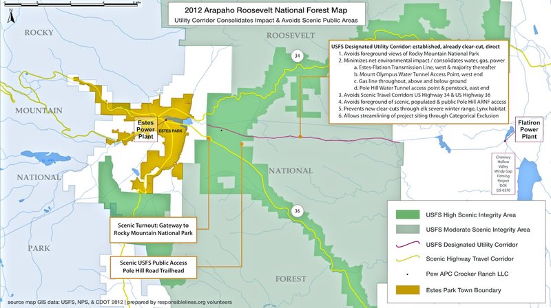
There are over 300 million people in our country who own Roosevelt National Forest. Our tax dollars pay for its maintenance. Our tax dollars are paying for the re-build of these power lines. Let’s not let our tax dollars get wasted an a publicly damaging re-route which accommodates a single private land owner to the public’s detriment (see map).

Here's how you can help:

Take Action Here: responsiblelines.org/takeac…
The public’s view from Roosevelt National Forest (Feb 2012) right next to where WAPA is proposing new clear-cuts and 10-story towers: here and along the scenic US Hwy 36, across the public access trailhead, across public campgrounds, and through Roosevelt National Forest where no utility corridor exists.
Evan18 Horenovsky · · Boulder, CO · Joined Mar 2012 · Points: 1

I just stumbled across this thread and became interested in what the result was here or the current status.  Could someone please provide an update here?

Jim T · · Colorado · Joined Jun 2012 · Points: 469

In December 2016 they picked the route mostly within the existing corridor and not along Hwy 36.
https://www.wapa.gov/newsroom/NewsReleases/2016/Pages/WAPA-selects-route-for-Estes-to-Flatiron-EIS.aspx

The final EIS was released in April 2018:
https://www.wapa.gov/transmission/EnvironmentalReviewNEPA/Pages/estes-flatiron.aspx

Evan18 Horenovsky · · Boulder, CO · Joined Mar 2012 · Points: 1

Great, thanks Jim

Guideline #1: Don't be a jerk.

Colorado
Post a Reply to "Massive power lines in front of Rocky Mountain…"

Log In to Reply
Welcome

Join the Community

Create your FREE account today!
Already have an account? Login to close this notice.

Get Started