
 Continue with onX Maps


ID 106554530 ·
·
Copyright Violation?


Rate Photo

Mike Howard
Sep 25, 2009
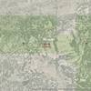
“USGS Topo Map for area. Hard to say if this independent map confirms the description of boundaries. This is the same as the map available at the ranger station. According to this, the boundary is closer to the base of Mosaic Rock. Regardless, private and public property is to be respected.”


![The Land Owner requests this waiver to be signed and mailed if climbing on private property. Click (twice) to open this image in browser to enlarge and print. PDF Available for download as [[PDF]]http://lamountaineers.org/Tres_Piedras/Tres_Piedras_Route_Guide.html](https://mountainproject.com/assets/photos/climb/106533337_sqsmall_1494117894.jpg?cache=1701315936)


2 Comments