
 Continue with onX Maps


All Locations >
Colorado
> Estes Park Valley
> Lumpy Ridge
> Pear
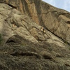
> Magical Chrome Plated… (5.7 5a 15 V+ 13 MVS 4b)


ID 106466217 ·
·
Copyright Violation?


Rate Photo


 4.5
from
2 votes
4.5
from
2 votes
Julius Beres
Jun 19, 2009
“I'm not sure what all of the lines are.
Looking at a guidebook topo, the original "natural line" is about 10 feet right of B in a corner system and is 5.7. (Option 1 in description?)
I believe B to D is option 2, and is shown as 5.9 in the guidebook topo. (D, the ass crack, felt significantly harder to me.)
Exit to C is shown as 5.6. I assume to get to C one can go up A or further left (options 3 and 4?).”


1 Comment