
 Continue with onX Maps
 Continue with Facebook


Lime Park (a.k.a. Lime Creek) Rock Climbing
| Elevation: | 9,115 ft |
| GPS: |
39.40728, -106.65542 Google Map · Climbing Area Map |
| Page Views: | 290,319 total · 1,207/month |
| Shared By: | Anonymous Coward on Jul 20, 2004 · Updates |
| Admins: | Alvaro Arnal, Leo Paik, John McNamee, Frances Fierst, Monty, Monomaniac, Tyler KC |
 Access Issue: 2023 Raptor Closure - Endless Wall
Details
Access Issue: 2023 Raptor Closure - Endless Wall
Details
In 2022: the closure ended. During monitoring, a tech saw no falcons/young on the cliffs or nesting area seen earlier that season. An adult flew around the main canyon & was calling. The young were able to fly, & the family was in the area but not nest dependent.
In 2022: from P. Nyland - the peregrine falcons returned in 2022 to nest in Jellystone, Lime CC. Thus, White River NF closed the area depicted in the attached Forest Order, effective 6/9-8/1/22.
2 peregrine falcons nested here in 2020 during a similar closure. In 2021, falcons did not nest in this area & a closure ended.
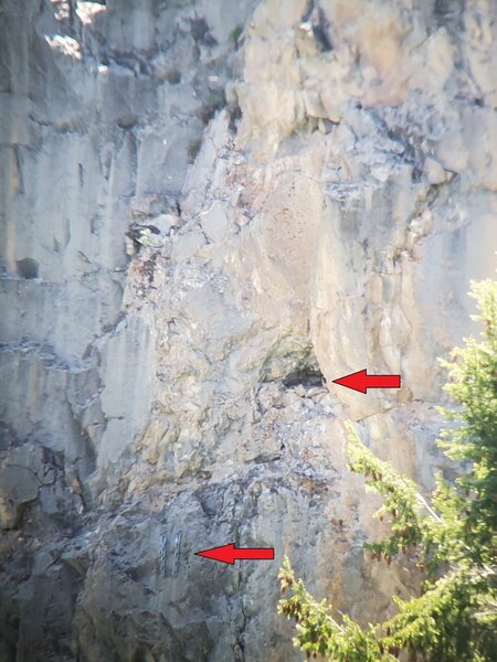
2 were attending a nest. During my last monitoring, both birds were highly agitated until I backed away from the cliff edge. The nest was in a location visible from access & climbing routes at the Endless Wall & Magic Forest. In 2020, climbing was possible at the Endless Wall during the nest & nest-departure phases, but that year the nest location made the pair & their young reactive & vulnerable to humans.
The closed area includes the cliff faces, cliff tops, climbing routes, & access routes to Magic Forest & Endless Wall. The cliff tops were in the closure, b/c we saw peregrines perched there. Closure info is posted at the start of the access from FR 400. Closure ended Aug. 1.

Older: as of 6/20/21, after speaking with P. Nyland, NF Biologist, the study to date showed no evidence of nesting. As a result, the NF anticipated no raptor nesting closures. If evidence of raptor nesting is found, the situation could change, but for now Lime CC & the nearby areas are open.
The White River NF proposes to establish a 5 year reg., a “Special Order,” restricting human occupancy surrounding a peregrine falcon nest site during the nesting period in Lime CC, Eagle County, Aspen-Sopris Ranger District, potentially from May 15 to July 31 each year based on nesting.
The proposed Special Order extends a short-term restriction from 6/1-8/1/20 after monitoring showed an active nest for the fourth year from 2016-20, & within the past two years in close proximity to popular climbing routes. The cliffs of Lime CC are unique & have the specific resources needed for local peregrine falcons to nest, lay eggs, & rear young. During this life stage, adults & young peregrine falcons can be disturbed by humans.
It is our intent to protect the area surrounding the nest site using science-based peregrine falcon information & monitoring. As possible, the restriction may allow for climbing & other human presence where this does not interfere with local peregrine falcons to nest, lay eggs, & rear young. As possible, the area to be restricted would immediately surrounding the nest site & adjusted in location if the birds shift their nest site during the 5 year restriction period. The proposed Special Order would be lifted on or before Aug. 1, depending on the status of the nest & the peregrine falcons present, & the Special Order would remain in effect until rescinded or until 8/1/25, whichever event occurs first.

How to comment:
You may comment on this proposal by replying to P. Nyland, Wildlife Biologist at 970-404-3156, philip.nyland@usda.gov or J. Schuller, Deputy District Ranger at 970-404-3163, Jennifer.schuller@usda.gov. Please provide comments by 5/24/21.
More information regarding the proposal, its rationale, & how to provide your comments is available by contacting the FS.
fs.usda.gov/project/?projec…
Thank you for your interest.
Phil Nyland
FS Wildlife Biologist
White River NF,
Aspen-Sopris District
p: 970-404-3156
philip.nyland@usda.gov
POB 309, 620 Main St.
Carbondale, CO 81623 fs.fed.us
Description

Getting There
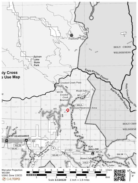
Continue past the lake on Forest Service Road 400 for approximately 8 miles to FS 507. ~1 mile after the lake, stay left at the fork. ~3 miles past Sylvan lake, you will reach Crooked Creek Pass. Continue straight. 2 miles beyond the pass, you will pass Crooked Creek Reservoir on the left. 1 mile past Crooked Creek Reservoir, turn left onto FS 507. Turn right onto Burnt Mountain Road after 0.4 miles. This is a total of 9.1 miles past Sylvan Lake, or 24.6 miles from I-70.
0.2 miles after the right turn, you will see the canyon below and to the west. Turn right into the canyon. There is a road on either side of Lime Creek. The Punch Bowl is on the East side of the canyon, and all other crags are on the West side. The West Road is more suitable for low-clearance vehicles. If you're camping, the East Road provides more secluded camp sites.
According to my atlas this area can also be approached from Basalt.
2021 Raptor nesting update

June 15, 2023: The White River National Forest has temporarily closed rock climbing to protect nesting Peregrine Falcons north of the Endless wall area of Lime Creek Canyon until August 1st.
Specific to the Endless Wall at Jellystone Park, the closure begins about 75 feet to climber’s right of the route Fruit of the Linen and extends about 2000 feet up the main canyon to a point about 180 feet north of the overhead powerline.
The closure order and maps are available at https://www.fs.usda.gov/detail/whiteriver/notices/?cid=STELPRDB5176138, see Aspen-Sopris Ranger District --> Lime Canyon Peregrine Falcon Nesting Closure.
Phil Nyland, Forest Service Wildlife Biologist, White River NF, Aspen-Sopris District, p: 970-404-3156, philip.nyland@usda.gov,
PO Box 309, 620 Main St., Carbondale, CO 81623, www.fs.fed.us.
Visitation Questionnaire
You are being invited to take part in a research study about the recreational use of Lime Park (Lime Creek) to better understand how individuals and groups use the area.
Click here to access the questionnaire.
The White River National Forest has identified Lime Park recreational area as a site in need of management due to the continual increase in use by recreationalists, especially the rock-climbing community. Lime Park is located in a remote area within the National Forest resulting in significant management challenges for the area, primarily impacts from recreational use such as increased human waste and habitat degradation.
This project will result in a recreational management plan and the formation of a “Friends of Lime Park” stakeholder committee to co-manage the area with the support of the National Forest. The project uses adaptive management strategies to ensure the area remains accessible to all, achieving a high-quality user experience with minimal negative environmental impacts within a remote wilderness region.
Classic Climbing Routes at Lime Park (a.k.a. Lime Creek)


Weather Averages
|
High
|
Low
|
|
Precip
|
Days w Precip
|
| J | F | M | A | M | J | J | A | S | O | N | D |
| J | F | M | A | M | J | J | A | S | O | N | D |
Photos


All Photos Within Lime Park (a.k.a. Lime Creek)
Most Popular · Newest · RandomMore About Lime Park (a.k.a. Lime Creek)
Printer-FriendlyWhat's New
Guidebooks (8)


58 Comments