
 Continue with onX Maps


ID 105944117 ·
·
Copyright Violation?


Rate Photo


 3.5
from
2 votes
3.5
from
2 votes
Ryan Brough
Apr 11, 2007
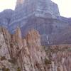
“Approach map to Sawtooth Canyon and Notch Peak:
Pull off highway 6/50 onto dark gravel road around mile marker 43. This road converges with a dirt road called the Tule Valley Road. This road leads to Painter Springs. From the highway, drive approximately 6.5 miles to a four-way intersection. Turn right onto the rough road and drive for about two miles and park in a clearing just before the streambed. If you brought a high-clearance vehicle with four-wheel drive that you don't mind scratching up, you can drive up the wash for another half mile to the wilderness study area sign. ”


Pull off highway 6/50 onto dark gravel road around mile marker 43. This road converges with a dirt road called the Tule Valley Road. This road leads to Painter Springs. From the highway, drive approximately 6.5 miles to a four-way intersection. Turn right onto the rough road and drive for about two miles and park in a clearing just before the streambed. If you brought a high-clearance vehicle with four-wheel drive that you don't mind scratching up, you can drive up the wash for another half mile to the wilderness study area sign. ”


![View from the top looking south toward <em>[[105916340]]</em>.](https://mountainproject.com/assets/photos/climb/109470469_sqsmall_1494351152.jpg?cache=1701318643)


1 Comment