
 Continue with onX Maps


ID 105806961 ·
·
Copyright Violation?


Rate Photo


 3.7
from
3 votes
3.7
from
3 votes
Peter Spindloe
Mar 17, 2006
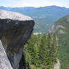
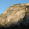
“This picture, taken from the side of Hwy. 99, a few hundred feet south of the main parking lot, shows most of the Chief's east facing walls. This picture doesn't do the size of the formation justice.
From left to right:
At the far left of the photo you can just see the top of the Apron (six pitches up, to give you a sense of scale).
Then there's the University Wall and Grand Wall areas. The Black Dyke is visible going through the big roofs.
The Dihedrals area is the darker section in the middle. Up and right from the Dihedrals you can see the Tantalus wall.
Finally, the Bulletheads are on the far right.”


0 Comments